From the Sootypaws blog
The Numbers
We did 13 soil tests on the site using Hach chloride test strips. In one large area, within a perimeter of torn plastic (approximately 15 by 100 feet), we found elevated chloride in 3 locations: greater than 650 mg/l at S5 (and nearby in two earlier tests), 333 mg/l at S6 and 136 mg/l at S7. This was along a line through the area of the site where the pit had been during drilling. We believe the black plastic is pit liner, used to wrap the solid drilling waste before the contents of the pit were shallowly buried under a few inches of soil. Pennsylvania requires 18 inches of cover, the Argonne National Laboratory recommends 3 feet of cover, West Virginia has no guidance.
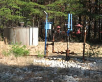
Here are some photos to show what we saw:

This photo was taken looking eastward with Molly barely visible in the background. The red circles show the position of some of the blocks with flags we set out around the perimeter of exposed black plastic.
The bare area in the foreground had the highest chloride concentration.

The black plastic stuck up out of the ground and was thick -- nearly impossible to tear.
There are deer tracks in the soil.

This is the same area as the first photo, looking westward. The S numbers point to small circles, their locations along a line about 28 feet apart from each other.
We took a sample from the same location as S5 but deeper for the laboratory analysis. The sample for S5 was collected from the surface, the sample for the laboratory was from 4 to 5 inches below the surface, entirely within the gray colored soil area that we felt was pit waste (patches of gray soil were evident in spots within the perimeter of black plastic).
Here's what the laboratory found for the requested tests:
|
|
Concentration |
CAS Number |
Chloride |
2550 mg/kg |
16887-00-6 |
|
||
Arsenic |
16 mg/kg |
7440-38-2 |
Barium |
203 mg/kg |
7440-39-3 |
Cadmium |
Not Detected |
7440-43-9 |
Calcium |
37100 mg/kg |
7440-70-2 |
Chromium |
27.9 mg/kg |
7440-47-3 |
Lead |
23.4 mg/kg |
7439-92-1 |
Magnesium |
6400 mg/kg |
7439-95-4 |
Sodium |
1230 mg/kg |
7440-23-5 |
|
||
Radium 226 |
1.57 pCi/g |
13982-63-3 |
Radium 228 |
1.35 pCi/g |
15262-20-1 |
Note: EPA considers chromium (CAS number 7440-47-3) as total chromium (Cr VI to Cr III at 1 to 6 ratio). Others treat the same CAS number as chromium III only.
Solid pit waste isn't uniformly homogenous. If we took a sample from another location it's possible that the results would be different. For that reason these numbers give an idea but not the whole picture.
The chloride concentration was higher than that shown on the operator's Discharge Monitoring Report for this well (the liquid waste was landsprayed) which had 2,125 mg/l. Milligrams per liter is roughly equivalent to milligrams per kilogram (and both are also called parts per million). We believe the chloride concentration in this location is still high because the pit liner is intact at the bottom. Chloride has the same mobility as water and won't remain in soil, certainly not for years unless there's something blocking its movement.
We were surprised to see the calcium, magnesium and sodium concentrations were so high. Generally, they are less than chloride (sodium about half) for liquid samples, such as liquid pit waste tested at 5 locations by the DEP in the mid-1980s. The high calcium and magnesium concentrations offset the sodium, giving the pit waste a moderate SAR (we wrote about SAR and the issue of high sodium in What Happened at Fernow).
Five heavy metals were analyzed. Cadmium could not be detected above the lab's effective test limit (0.19 mg/kg). A more precise test method would be required. The remaining four, arsenic, barium, chromium, and lead, have concentrations that may or may not be within West Virginia soil background levels. That's more research we need to do, though we've seen concentrations of lead at 28 to 42 mg/kg in uncontaminated soil elsewhere in this state.
The metal we're focusing on is arsenic. Some states require notification if arsenic is found in soil above 5 mg/kg (Alabama, Delaware -- 2 ppm residential, New Mexico and South Carolina). Kentucky's industrial soil screening level is 0.185 mg/kg (other states have lower standards, or higher -- especially for residential areas). A report providing information about state regulations covering arsenic in soil for 34 states is available online.
So arsenic looks like it's a problem. Fortunately, the radium 226 and 228 concentrations are within acceptable levels. Radium 226 is a long-lasting isotope which breaks down to radium 228 and eventually becomes radon.
What complicates the issue is the state's approach to drill waste. Well drilling and production are assumed to have a minimal impact on the surface. After a well is plugged and equipment is removed, the surface returns to its original state -- to be used as farmland, revert to forest, or become a home site (we've seen trailers moved onto a plugged well site after the tank and equipment were removed).
As far as we know, no one has tested pit waste solids in this state and the DEP has no idea actually what is being buried. If they've known, they've certainly not told anyone.
This well and pit are about 200 feet from a residence and vegetable garden, so a bad pit is a problem for that homeowner. The pit is about 300 feet away from a spring-fed cistern down in the hollow, so a bad pit is a problem for another homeowner. What will happen to the site a hundred years from now will be a problem for the possible future homeowner living on the site with a garden and children digging in the soil. Somehow this isn't an issue for the state or operator.
We don't think the state can ignore pit waste any longer, or pretend, once it's lightly covered up, the problem has gone away.
The next post will be about risk assessment for this site.
Posted on Sep. 26th, 2009 at 07:43 pm
Gas Well Site Visits
Examining Well Sites
How We Examined Well Sites
Environmental Assessment
Table with Links to Wells Visited
47-039-05714 Environmental Assessment
47-079-01492 Environmental Assessment
47-039-02026 Environmental Assessment
Gas Well Study is the examination of natural gas wells in West Virginia.
Underground Injection Control Class 2 Wells
These wells are used either for the disposal of oil and gas liquid waste or for the enhanced recovery of oil or natural gas.
Gas Well Study Site Visits
Annual reports, environmental assessments, and individual well information.
YouTube Videos
Select videos from the Gas Well Study YouTube channel.
What Happened at Fernow
An investigation into what caused the vegetation death in the land application area after landspraying hydraulic fracture flowback waste.
The Spill at Buckeye Creek
An investigation into a spill from a Marcellus well site into Buckeye Creek in Doddridge county.
The Details
Plunger Lift Technology on Gas Wells
Fluids Brought to the Surface during Production
Plugging a Well
How To Read a Lab Report
Information the Completion Report Provides
Casing and Cementing