How We Examined Sites
We began examining well sites in our area in 2008 after an operator marked a location for a natural gas well on our property. We wanted to get an idea about what we could expect in terms of forest clearing, roads and maintenance, and other issues. Our primary guide for these things was the West Virginia oil and gas construction erosion and sediment control manual (this manual was revised in 2012). This manual's use by operators was required by state law. We also started to look at state and federal laws requiring secondary containment for storage tanks containing petroleum products and in this state also those tanks containing produced water or brine.
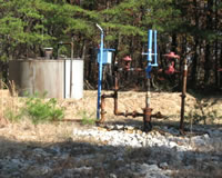
Our focus in 2008 was size of clearing for a well pad, vegetation on the pad, access roads, and maintenance issues. As we looked at wells we began to get an idea of other issues we should be concerned about. Why were so many well pads bare of grass, for instance. Even though required by state regulation, many wells we saw did not have tags on the wellhead showing the API number. This sheet gives an idea of the major issues we were seeing in 2008 (note that the URL given on the sheet for the Gas Well Study is not current).
Our examination of wells and well sites shifted dramatically in 2009 after extensive study of state laws and regulations, construction and maintenance practices required by other states for oil and gas, construction practices recommended by the oil and gas industry, and environmental literature.
We developed a worksheet to be used when examining a well site (this is the latest form of that sheet) and processes that included measurement of soil and water contamination on or near well sites. We also realized that an examination of a well site required not just looking at the well pad itself but also the area surrounding that pad.
We introduced new tools that we used when examined a site -- a GPS device (which turned out to be not as accurate as we wished), a home made device to measure incline angles, measuring tapes, tools for collecting soil and water samples, and USGS paper quad maps. We created online classes for the West Virginia Sierra Club which collected materials and provided context for those wanting to know more about oil and gas development in West Virginia.
By 2011 we began to have an idea of the types of problems we would see when visiting well sites and created our 30 Wells report. The last addition we made to our toolbox was a video camera for recording a visual and spoken narrative when visiting a well site. YouTube became a tool for presenting videos about issues or features of a well site to a wider public.
Gas Well Site Visits
Examining Well Sites
How We Examined Well Sites
Environmental Assessment
Table with Links to Wells Visited
47-039-05714 Environmental Assessment
47-079-01492 Environmental Assessment
47-039-02026 Environmental Assessment
Gas Well Study is the examination of natural gas wells in West Virginia.
Underground Injection Control Class 2 Wells
These wells are used either for the disposal of oil and gas liquid waste or for the enhanced recovery of oil or natural gas.
Gas Well Study Site Visits
Annual reports, environmental assessments, and individual well information.
YouTube Videos
Select videos from the Gas Well Study YouTube channel.
What Happened at Fernow
An investigation into what caused the vegetation death in the land application area after landspraying hydraulic fracture flowback waste.
The Spill at Buckeye Creek
An investigation into a spill from a Marcellus well site into Buckeye Creek in Doddridge county.
The Details
Plunger Lift Technology on Gas Wells
Fluids Brought to the Surface during Production
Plugging a Well
How To Read a Lab Report
Information the Completion Report Provides
Casing and Cementing