From the Sootypaws blog
Problem Well
Molly and I have been revisiting gas well sites we looked at in 2008. We've seen mostly positive changes -- for instance, many of the wells' condensate storage tanks now have the required secondary containment dikes.
Something we weren't able to do in 2008 was examine sites more closely for pollution. This time we performed quick environmental assessments and have collected samples or tested surface water at three sites.
One well we revisited, 47-079-01314, has a number of problems. It was originally drilled as a deep well to the Newburg and Lockport formations but because of brine problems was plugged back to the bottom of the Onondaga limestone formation. It's still a deep well, by law, but the gas producing formations are Marcellus and Huron Shale above the Onondaga. (Here's a copy of the well's completion report filed by the operator with the state.)
Operators have to file production figures annually with the state's Office of Oil and Gas. When the state doesn't receive production figures within a period of time, the well is considered abandoned and must be plugged. West Virginia bases its severance tax on these production figures.
Production figures for this well haven't been reported to the state since 2005 and the state's databases show this producing well as "abandoned." Since no production has been reported, it's hard for us to tell if the operator paid the severance tax for years on this well.
When we visited this well last week we noticed pieces of black pit liner sticking up from the soil in various spots along a 85 foot long line. Near one end of this area was a small pothole filled with water and we took a sample from it to test for chloride. Using a Hach low range chloride test strip we found a concentration of 356 mg/l. Another location on the pad with standing water, well away from the exposed black plastic area, showed just a trace of chloride, which is what we'd expect from soil or water not contaminated.
We'll return to this site when it is drier and do a complete assessment.

Molly is on the barely vegetated pad looking for black plastic pit liner. A piece is circled in red.
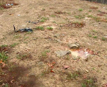
A piece of pit liner is on the left and in the right foreground is the small pothole we took the sample from.

More pieces of pit liner. Because the soil was wet it wasn't easy to spot exposed pit waste. The gray patch of soil between the two clumps of liner may be pit waste.

The Hach test strip in a plastic cup with sample. It takes only a few minutes to do a test in the field this way.
More soon!
Posted on Nov. 21st, 2010 at 05:33 pm
Gas Well Site Visits
Examining Well Sites
How We Examined Well Sites
Environmental Assessment
Table with Links to Wells Visited
47-039-05714 Environmental Assessment
47-079-01492 Environmental Assessment
47-039-02026 Environmental Assessment
Gas Well Study is the examination of natural gas wells in West Virginia.
Underground Injection Control Class 2 Wells
These wells are used either for the disposal of oil and gas liquid waste or for the enhanced recovery of oil or natural gas.
Gas Well Study Site Visits
Annual reports, environmental assessments, and individual well information.
YouTube Videos
Select videos from the Gas Well Study YouTube channel.
What Happened at Fernow
An investigation into what caused the vegetation death in the land application area after landspraying hydraulic fracture flowback waste.
The Spill at Buckeye Creek
An investigation into a spill from a Marcellus well site into Buckeye Creek in Doddridge county.
The Details
Plunger Lift Technology on Gas Wells
Fluids Brought to the Surface during Production
Plugging a Well
How To Read a Lab Report
Information the Completion Report Provides
Casing and Cementing